I’ve been thinking for a while that I needed to explain the geography of El Salvador and Berlín. When I first learned that my church was involved with mission work in El Salvador I had to stop and think about where that was. After that I slowly began to learn about the different departments of El Salvador and the municipalities within those departments and much more. Since I know it’s all really confusing I thought it’d good to share with everyone some of the geographics of El Salvador.
El Salvador is located in Central America. The countries of Belize, Guatemala, Honduras, Nicaragua, Costa Rica, Panama, and El Salvador make up Central America. El Salvador is bordered by Guatemala, Honduras, and the Pacific Ocean. It is the most densely populated country in Central America with 8,124 square miles and around 6.9 million people. To give you some perspective, the state of Iowa has 56,272 square miles and a little over 3 million people.
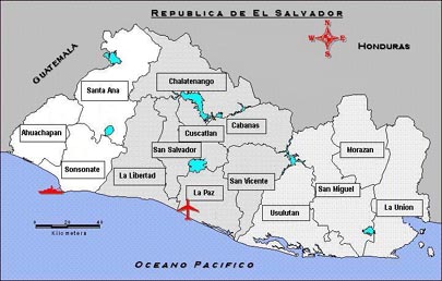
Just like the US is divided into states, El Salvador is divided into departments. There are 14 departments in total. I live in the department of Usulután. Like states in the US are divided into counties, the departments in El Salvador are divided into municipalities. Within the county are several little cities, and within the municipality are several little towns. Here in the municipality of Berlín we have the main city of Berlín and also 17 cantons (towns).
Going back just a little. Each county has a county seat just like each municipality has a main city. The county seat of Polk County is Des Moines. The main city of the municipality of Berlín is Berlín. More perspective: The city of Des Moines has 200,538 people and 77 square miles. I’m not sure of the exact square mileage of Berlín though I know it is much smaller and has about 9,000 people. Around 4,500 live in the city of Berlín and 4,500 live in the cantons around Berlín.
Now for some more confusion. Just like the city of Des Moines is divided up into different districts and neighborhoods, Berlín is also divided up. In Des Moines we have different areas like Waveland Woods, Beaverdale, Roosevelt district, East Village, etc. Berlín is also divided up into barrios (neighborhoods) and colonias (colonies). I’ve yet to completely figure out how exactly the city is divided but I do know that I live in Barrio La Parroquia.
Below is a little table that will hopefully make things clearer. Just an FYI: I’m using the state of Iowa and the city of Des Moines as example because that’s where I’m originally from. My exact location:
Country Country
(País) (País)
USA El Salvador
State Department
(Estado) (Departamento)
Iowa Usulután
County Municipality
(Condado) (Municipio)
Polk Berlín
County seat City
(Capital de Condado) (Ciudad)
Des Moines Berlín
Neighborhoods Colonies, Neighborhoods, Cantons
(Barrios) (Colonias, Barrios, Cantones)
Waveland Woods Barrio La Parroquia
If this blog has only added to your confusion then I apologize. I admit that my head started spinning as I was writing the blog. It took me a long time to figure this all out and sometimes it’s still not clear. Hopefully the pictures below will do a better job explaining things than me.
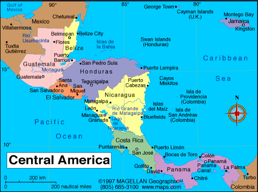
Central America
Country of El Salvador with the 14 different departments

The Department of Usulutan is highlighted

The Department of Usulutan divided into municipalities

Map of Usulutan

Map of the municipality of Berlin
1 comment:
This was really interesting and helps to understand exactly where you are. It was a good idea to relate it to Iowa and Des Moines.
Post a Comment